ECOS Data Services
ESA Species Critical Habitat Boundaries
Technology: ESRI ArcGIS Feature and Tile Services
U.S. Fish & Wildlife Service (FWS) designated Critical Habitat boundary polygons and lines.

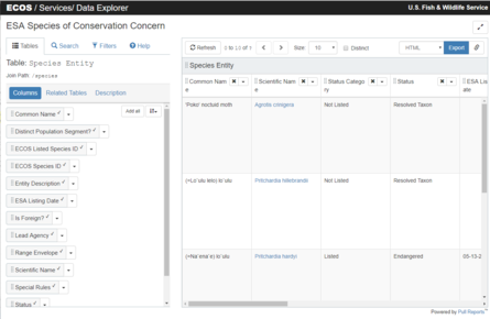
FWS Species Data Explorer
Technology: Pull Reports / REST
Species managed by the U.S. FWS pursuant to its responsibilities under the Endangered Species Act.
The service includes listing, taxonomy, and related Federal Register publication information.
Quick links:
- Data Explorer: Use the data explorer to construct custom queries into the REST-API. The explorer permits joining data, adding filters, sorting, and changing the export format type (e.g HTML, XML, JSON, or CSV).
- Example request: All ESA Threatened & Endangered species listings in html, json, xml, and csv.
Report of Petitions Sent to the U.S. FWS Regarding Listed Species
Technology: Pull Reports / REST
All U.S. FWS reported petitions.
Quick links:
- Summary Report: A prepared report with the default columns for Petitions Received by the Fish and Wildlife Service.
- Data Explorer: Use the data explorer to construct custom queries into the REST-API. The explorer permits joining data, adding filters, sorting, and changing the export format type (e.g HTML, XML, JSON, or CSV).
- Example request: All reported Petitions in html, json, xml, and csv.
U.S. FWS Species With Recovery Documents
Technology: Pull Reports / REST
U.S. FWS Species with their associated recovery documents.
Quick links:
- Data Explorer: Use the data explorer to construct custom queries into the REST-API. The explorer permits joining data, adding filters, sorting, and changing the export format type (e.g HTML, XML, JSON, or CSV).
- Example request: All Species with Recovery Documents in html, json, xml, and csv.
IPaC Location API
Technology: REST
The IPaC Location API enables external applications to create and request data from IPaC projects through a REST-ful interface.
The returned data includes information about ESA Threatened & Endangered Species, Migratory Birds, and sensitive wetlands
in the given location.
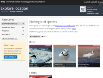 Example Location API output.
Quick links: